


The Oyster Catcher stage trail run follows the famous Oyster Catcher hiking route, from the Gouritz River Mouth to Mossel Bay via the St Blaize hiking route along the Southern Cape coastline in the Garden Route of South Africa. The Oystercatcher trail is a world acclaimed experience, a lighthouse to lighthouse trail rated by National Geographic Traveller as “One of the Top 50 tours of a lifetime” with the BBC classing it as one of “30 Unforgettable hikes to do…” and the local Getaway Magazine rating it as one of the top 5 South African hiking routes.
The Oyster Catcher trail run is primarily designed for trail runners looking to complete their first multi-day stage race. The distances covered are manageable and the terrain is made up mainly of single track (hiking trails) and beach running, with some technical areas to add variety. Due to the sensitivity of the area, a limited number of only 300 runners can enter each year, so don’t miss out!
Course details
Course highlights
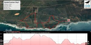
Day one took the runners along a 20km circular route into the Gourikwa Private Nature Reserve where they ran past the towering Ystervarkpunt (Porcupine point) lighthouse, on mainly coastal and jeep tracks. Day two brought some more technical areas over another 20km with runners starting at Gouritz River Mouth, on the opposite side of the river, ending in Boggemsbaai. On the final day, the route wrapped around the cliffs of the St Blaize hiking trail in Mossel Bay, starting at Dana Bay beach to The Point, Mossel Bay. The route passes the Pinnacle Point Caves where recent Mitochondrial DNA research has shown that all humans alive today descend from a small population that lived here between 150,000 and 200,000 years ago. New archaeological research has revealed that at least some of those people lived in the area now known as Mossel Bay.
Start address: Boggoms Bay, South Africa
Finish address: Boggoms Bay, South Africa
Route map

Comments